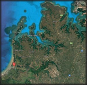
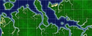
Named after a member of our family, Hunters Retreat is located about an hours drive from Darwin, Northern Territory. Situated high and dry above the Bynoe Harbour storm surge, Finniss River floodplain and billabongs. All weather, all season perfection.
Privately owned acreage currently undergoing revegetation and development. A secluded, tranquil, private piece of the Northern Territory. Located within an hours drive of Darwin. No crowds, no hustle and bustle, just the sounds of nature. An easy and convenient location to explore a one-of-a-kind unspoilt natural environment and enjoy a piece of the NT’s paradise!
Help us work towards providing an experience you too can enjoy by taking our survey.
Australia’s Northern Territory is teeming with exotic birdlife, mammals, reptiles and marine life. The Finniss River and Bynoe Harbour included. The Finniss River coastal floodplain, about 70 km south-west of Darwin is dominated by seasonally inundated grassland and sedgeland with areas of paperbark open-forest. The Finniss River floodplain is also of international significance. This site is listed as a wetland of national significance in the Directory of Important Wetlands in Australia.
The area supports very large numbers of waterbirds, including more than 1% of the world’s populations of Magpie Geese and Pied Herons, and high densities of many other waterbird species. It supports important breeding activity by Saltwater Crocodiles, Magpie Geese and other waterbirds, and three large waterbird breeding colonies are known to be located in paperbark swamps on the floodplain. Approximately five threatened birds and one threatened plant species also call this area home.
Of national importance are the vulnerable and threatened species of:
Plants – Monochoria hastate
Vertebrates – Australian Bustard Ardeotis australis, Masked Owl Tyto
novaehollandiae kimberli, Partridge Pigeon Geophaps smithii, Red Goshawk
Erythrotriorchis radiatus, and Yellow-spotted Monitor Varanus panoptes.
Cycas canalis subsp. canalis on the other hand grows prolifically only in the in the Darwin Coastal bioregion. Wallaby are also very abundant.
Less than 1000 ha of mostly dry rainforest occur in this site, especially in coastal areas near Stingray Head. Most of the rainforest occurs
as small patches (<10 ha) but one significant patch is >100 ha.
Floating grass mats of the billabongs of the Finniss and Reynolds Rivers not destroyed by buffalo, provide an important habitat refuge and source of food for a range of fauna in the dry season, especially crocodiles. There are more crocodiles in the Northern Territory than anywhere else in the world.
Although the Finniss Sub-Region is an establishing rural living area and an important recreational area for Darwin residents and visitors, careful growth and development is required to preserve the very reason it is so popular!
Important wildlife breeding sites and concentrations of rare, threatened or endangered flora and fauna species are worth protecting.
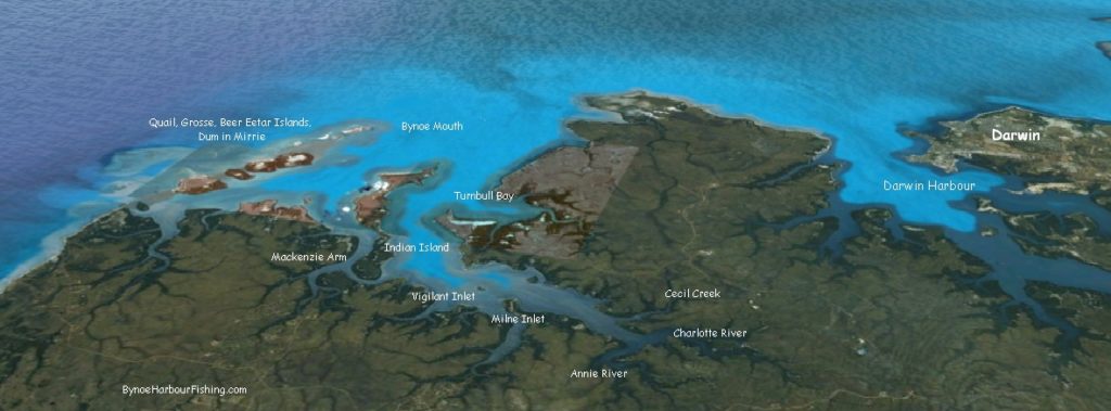
There are at least half a dozen boat ramps in the Finnis River & Bynoe Harbour area.
MILNE INLET – At Milne Inlet. Turn off Fog Bay Rd along Bynoe Haven Rd past Sand Palms Roadhouse and then Milne Road. Best with tides higher than 3 meters.
STINGRAY HEAD BEACH LAUNCH – Turn off Cox Peninsular Rd onto Fog Bay Road. About 55 km along Fog Bay Rd the road makes a sharp turn where the large Dundee sign is. Instead of heading to the lodge, follow the dirt track to Five Mile Beach.
DUNDEE – Turn off Cox Peninsular Road, the ramp is about 60km down Fog Bay Road. It is best to launch the boat with tides above 3 meters.
SIX PACK CREEK – At Mackenzie Arm. Turn off Fog Bay Road along Barramundi Drive. Best with tides higher than 2 meters.
At Mackenzie arm. Turn off Fog Bay Road along Dundee Road. Best with tides higher than 2 meters.
MOUTH OF ANNIES – If you are heading towards Cox Peninsular driving along Fog Bay Road there is a dirt track on the left 1.8 km past Lenny Creek. Follow the track to the end. Need a 4WD as it is necessary to drive onto sand to access launch site.
MOUTH OF FINNISS – Drive along 5 mile beach to the mouth of the Finniss. Launch boat off the beach – or – with permission from the Professional Fisherman’s Camp. Ramp is a couple of kilometers upstream continuing along a track from the mouth of the Finniss
River Road FINNIS River – Not Tidal. Take Hardcastle Road which is 500m before/after SandPalms Roadhouse on Fog Bay road then turn right about 3km along and go all the way down River road. River road and adjacent land floods in the wet season making access impossible for large periods of time. Check the NT Road Reports page and look for restriction alerts like this:
2017 Road Report Website Restrictions
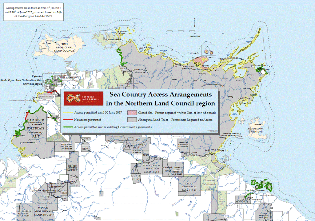
In December 2016 The Northern Land Council declared that a permit is required in relation to the areas marked in red on the Sea Country Access map. This is regardless of the six month waiver until 30 June 2017 on the requirements for a permit.
Arrangements in the Northern Land Council Region map, include:
…..(b) those parts of the Delissaville/Wagait/Larrakia Aboriginal Land Trust, more particularly described as the upper Finniss River.
Northern Land Council Sea Country Access Arrangements in the Northern Land Council region
It was supposed to be that from 1 July 2017 all commercial fishing operators and recreational fishers will require permission from Aboriginal land owners and the Northern Land Council (NLC) through the grant of a licence or permit to fish in tidal waters over Aboriginal land except in permitted access areas. But typical NT, this still doesn’t appear to be fully resolved!
Note: The Finniss River, access and fishing at River Road/Hardcastle road, has been highlighted as “No Access Permitted”. Time will tell as to whether this is fully implemented.
Crab Claw Island Resort– Private boat ramp to access the fabulous fishing. Turn off about 24 km from Cox Peninsula Rd – Fog Bay Road intersection. Dirt road – well sign posted. Great accommodation too!
Safety First! Make sure you have sufficient life jackets for every person on the boat.
Don’t go alone. Besides the safety aspects, it’s more fun. There are lots of dangers, don’t take risks in the Top End.
Check off the requirements at the NT Government Marine Safety site here.
Have the latest EPIRB – digital 406 MHz and it’s registered.
During the dry season in the Top End, weather conditions are pretty constant and ideal for fishing. During the wet season (November to May), the weather can change suddenly. Always check weather forecasts before departure. Always keep an eye on conditions whilst your pulling in that big fish! Find sheltered estuaries, creeks etc to ride out a storm should you get caught. Be aware winds and swells can blow in very fast.
Never choose to enter any water in the Top End no matter how deep or shallow.
Salt water crocodiles can be found in both fresh and salt water everywhere.
Take care how and where you gut that fantastic fish! Don’t attract crocodiles by leaving food scraps around. Even fresh water crocs can bite!
Fill your boat a day or two before your planned departure. Don’t fill on the day. Fish will stay clear of the smell of fuel if you get some on you and subsequently your line and bait.
Don’t let fuel sit too long. In the tropical humid atmosphere petrol will absorb the moisture from the air and you may end up with engine problems. Make sure petrol caps are tight.
Similarly put sun screen on before departure and wash hands well with soap before leaving shore. Fish won’t bite bait affected with sun screens, especially those that are scented. Cover up. Use wide brim hats and long sleeves. The tropical sun burns!
Top End waters lined with mangroves and mud flats are the breeding grounds for mosquitoes, midges and sandflies. Flies come from nowhere. Spray with a reliable deterrent again before departure. Always keep some handy. It’s no fun getting eaten alive – fish or no fish.
Refrain from smoking whilst fishing. Firstly your boat is full of petrol that could ignite, but again, fish are not nicotine adicts and they will smell you a mile away.
Check your anchor chain and rope. D shackles have a tendency to work loose. The last thing you want is to throw your anchor over board only to find on its retrieval – your anchor’s gone.
Know your bag limits for different fish species. Check out the info here.
Check and know your tide times. No run – No fun! Best to fish on the change of a tide. In the Top End, 6-7m tide changes are common. Be aware that sand bars and rocky reefs may be just below the water in low tides. What water you travelled over an hour ago, may now be dangerous.
Heard about that big fish that got away? Too many Times? Suggest use braid rather than filament fishing line.
Use quality fishing leader line. Many a good fish has got away by breaking the line at its weakest point.
Way Points: Good starting point but also use navigation, depth sounders to finely adjust your boat to the edge of a reef, ledge or wreck, not directly over a hole etc.
Use freshest bait you can get. Don’t thaw and refreeze multiple times. Fish are picky eaters!
Always clean your boat, rods, reels, tackle, immediately at the end of each day no matter how tired you are! Your fishing gear will last longer and be ready as soon as the fish are biting. Fishing is enjoyable, exciting, but all that fresh sea air and sun can be tiring. Plan you travel and clean up taking this into account.
Take plenty of drinking water. The tropical sun and climate does take its toll, especially out fishing for a couple of hours.
Lures: Use heavy fly gear and medium sized fishing lures in bright bronze or gold metallic colours
Trolling and Casting: Use medium weight baits and lures (These won’t get blown and knocked around like smaller, lighter varietties.)
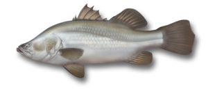
Peak Wet Season: December to March. Recommend cast from boats anchored in waterways close to banks and submerged logs
Dry Season: May to November. Try fresh water lagoons and rivers
Build Up: October to December. Barra are active as water temperatures rise in freshwater lagoons and in salt water estuarine waterways.
Tidal Rivers: Fish at the end of run-out tides
Estauries and Salt Water Creeks: Fish an hour or two either side of a low tide And when you hook a Barramundi, be prepared for an exciting battle of wits and strength with a worthy opponent.

 Australia’s Northern Territory is teeming with exotic birdlife, mammals, reptiles and marine life. The Finniss River and Bynoe Harbour included. The Finniss River coastal floodplain, about 70 km south-west of Darwin is dominated by seasonally inundated grassland and sedgeland with areas of paperbark open-forest. The Finniss River floodplain is also of international significance. This site is listed as a wetland of national significance in the Directory of Important Wetlands in Australia.
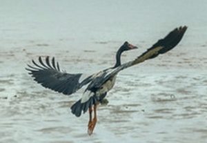 The area supports very large numbers of waterbirds, including more than 1% of the world’s populations of Magpie Geese and Pied Herons, and high densities of many other waterbird species. It supports important breeding activity by Saltwater Crocodiles, Magpie Geese and other waterbirds, and three
 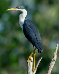 large waterbird breeding colonies are known to be located in paperbark swamps on the floodplain. Approximately five threatened birds and one threatened plant species also call this area home.
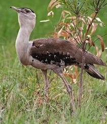 Masked Owl Tyto
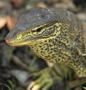
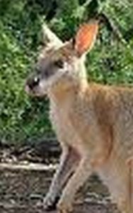 Wallaby are also very abundant.
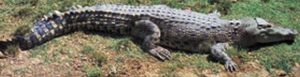 Floating grass mats of the billabongs of the Finniss and Reynolds Rivers not destroyed by buffalo, provide an important habitat refuge and source of food for a range of fauna in the dry season, especially crocodiles. There are more crocodiles in the Northern Territory than anywhere else in the world.
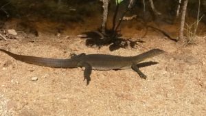
 There are at least half a dozen boat ramps in the Finnis River & Bynoe Harbour area.
 Trolling and Casting: Use medium weight baits and lures (These won’t get blown and knocked around like smaller, lighter varietties.)