Named after a member of our family, Hunters Retreat is located about an hours drive from Darwin, Northern Territory. Situated high and dry above the Bynoe Harbour storm surge, Finniss River floodplain and billabongs. All weather, all season perfection.
Privately owned acreage currently undergoing revegetation and development. A secluded, tranquil, private piece of the Northern Territory. Located within an hours drive of Darwin. No crowds, no hustle and bustle, just the sounds of nature. An easy and convenient location to explore a one-of-a-kind unspoilt natural environment and enjoy a piece of the NT’s paradise!
Help us work towards providing an experience you too can enjoy by taking our survey.
A lot of accommodation offered in the Bynoe, Finniss River and Dundee areas are offered by people who have lived for a while in the immediate area. They know the seasons and how the environment changes during the year. They know the risks and adjust accordingly. With great incite they offer affordable and considerate locations to enjoy.
However, there are some, who see a quick buck and develop under the auspice of “Eco Friendly” without any due consideration for the surrounding flora/fauna, environ, guests or neighbours. Like so many places today, they haven’t lived in the surrounds and have no idea. Business comes before anything else. Don’t be fooled by their glossy pictures or marketing strategies, it’s all gimmicks & hype with little if any basis to their claims! Do your homework before deciding to part with your hard earned dollars. Think twice about lining the pockets of those that don’t care about anything but the money unless you make the conscious informed decision to do so. According to our survey, the majority of respondents want a quiet, safe, self-catering family vacation/accommodation, not hoon-ville, rowdy partying or large expensive resorts.
Some Resorts/Retreats may cite function/education facilities with bars/restaurants etc. but that means noise, excess lighting and traffic! Ok if you are in party mood, but if not are you prepared to pay a high price for high end or luxury accommodation only to find some arrogant group booking taking over the whole place day and night with no regard to yourselves? How would you feel if you booked a week’s holiday with the focus of relaxation only to find 20-40 school kids running a muck on a school camp! Eco-Friendly being just token words as our wonderful fauna that we want to see and appreciate is not necessarily going to stay around organised (or disorganised) chaos. They are just pushed further and further away into smaller and smaller locals! Accommodation star ratings mean nothing to our fauna.
Have you seen sites announcing themselves as eco-friendly but displaying pictures of people tracking wildlife with guns at the ready and implying shooting/hunting safaris, especially as they rip up the ground on quad bikes? That’s really reducing, minimising, or excluding harm upon flora/fauna and ecosystems or the environment isn’t it? NOT! I visited one website that stated there were kangaroos to see at their place within an hour’s drive from Darwin. Sorry to spoil the illusion, but there are no kangaroos just wallabies in the top end! They really know their stuff! Ever seen the environmental impact reviews of these places? No? You’re not likely to either!
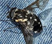
These “out of towners” won’t let on about and support you with the sand flies,
Annoying March Flies.
mosquitos, march flies, wasps, spiders, snakes and other undesirables either which are more prevalent at certain times of the year. Yes we may know about the dangers of crocodiles but your holiday vacation will be very uncomfortable if you and yours are covered in itchy welts for the whole time. Just imagine your wedding party bathed in a swarm of blood hungry suckers or your honeymoon ruined by constant itching. It’s also an hour or more to medical assistance! Want to listen to pig hunters shooting day and night?
Besides the usual, here are a few things you should consider when booking accommodation in the Bynoe, Finniss River and Dundee locations:
Who manages the accommodation? Is it managed by paid staff or local owners?
Are staff/owners easily available for immediate assistance? On site, local area, back in Darwin?
What insurance and in particular liability insurance does the accommodation have?
How many camping/caravan/room/cabin sites are available? The more there are the more potential for noise, lighting and disruption if quiet and tranquil is your goal.
Is there private or shared bathroom facilities? Internal or external?
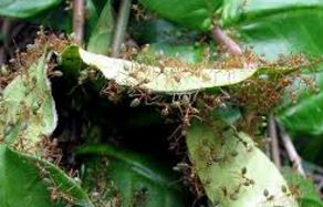
Is the accommodation nestled within trees and bushland? Overhanging branches? Great for shade but branches drop and so does the wildlife. Ever woken up in a green tree ants nest!
Green Tree Ants Nest
If a bush fire was to approach, would you be safe?
What shade structures are there for everyone or privately?
Is the accommodation roofing and under floor areas accessible to wildlife like snakes/spiders to crawl in/on or under?
Are there great looking low set tropical/native bushes around camp sites or guest accommodations? Great places for snakes to hide!
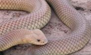
Northern Brown Snake: Highly venomous snake. Known to inhabit the Finniss River area.
Is the site well cleared with easy line of sight for nature’s intruders i.e. snakes? Or might you suddenly have an encounter at close range?
Are there private cooking and BBQ facilities including kitchen or are you forced to eat at the sites restaurant or travel some distance? What precautions have been taken for opportunistic ants?
What parking areas are available close to accommodation sites? Room for car and boat or caravan? What is the security like?
How far is it to launch a boat? Are there boat ramps accessible dry and wet seasons?
How far are you away from a water source? The closer you are the more potential for problems. Fresh or salt water. Will the water source rise in the wet season? If so be prepared for everything to move up to join you too!
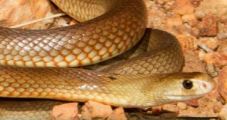
King Brown Snake : One of the longest venomous snakes in the world. Recently spotted on Hardcastle road.
Rising flood waters, rivers and billabongs can smell. Accommodation close to or over water sources can smell and develop mold. They may look inviting in a picture but your nose won’t know till it gets there!
Are water sources on the property or close by protected by fencing or other deterrents so croc accidents are minimised and children can’t easily access either? Crocs do move around some distances.
Where is the septic tank? Are the wet season rains and rising water tables going to over whelm it? There is no town sewer system in these areas. That fish you just caught and are cooking– what’s it been swimming in?
Is the site hilly? Will there be lots of walking up and down slopes/stairs? Does the accommodation cater for the disabled?
If the site is on a significant slope are the grounds terraced or has the site been cleared retaining the original landscape. Wet season rains can contribute to significant erosion of cleared lands if not managed well.
How good are walking paths or bike tracks? Again erosion issues and potential for loosing ones footing? Turning an ankle can be painful!
Can you control the outside lighting? Is there excess lighting that will attract flying insects? Insects bring cane toads and other frogs and in turn this brings snakes.
Does the accommodation have bar facilities? Be prepared for drunken idiots stumbling around! If BYO, then this can be just as bad if you’re not looking for a booze up!
Does the accommodation offer a swimming pool? Are you prepared for noise!
Does the Retreat/Resort offer guest motor bike or quad bike rides? More noise, dust etc.?
Does the Retreat/Resort offer night walks? Potentially more light, noise and carry-on.
Do you have to buy insect repellent or sprays or does the accommodation offer free of charge? There isn’t much opportunity to buy locally.
Is the accommodation positioned close to a road or set well back? On a corner? Nothing worse than traffic noise and dirt road dust.
Does the accommodation have fly screen protection? Is there al fresco dinning/bar without necessary protection from insects etc. The last thing you want to swallow is the natives!
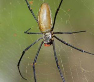
Golden Orb Spider
Does the accommodation have air-conditioning or fans or both? A nice enclosed breeze way? It can get hot and steamy in the top end!
How is waste managed? Accumulating food scraps and other wastes attract mice, rats and again snakes.
What is the water source for the accommodation use? The best is rain water. The worst is river/billabong/dam water.
Where is waste/grey water going? What’s that puddle you just stepped in?
Is the electricity provided by generators? These can be noisy. Does it have solar power?
Is mud racing/motorbike riding circuits available in wet areas? Have you heard of Melioidosis?
Are you in an area renown for pig or goose shooting/ hunting i.e. Finniss River and associated flood plains? Gun shots can be unnerving for the unprepared.
Do you want a place that excludes pets? Can you take your beloved canine, and if so what protective measures are in place? It’s no fun for “Fido” if he has to be chained up all the time! The prey instinct is often high in many breeds and they are likely to chase wallaby well out of your sight. Even trained hunting dogs are lost, never to be seen again. Good fencing etc is a must. Keep them away from water. Many a dog has been lost to a croc attack!
Don’t be taken in by the use of marketing terms such as “ECO”. We humans impact wherever and whenever we go.
Whatever you want to do, wherever you go and stay in this unique place in the world, please choose wisely and be safety and environmentally conscious!
Australia’s Northern Territory is teeming with exotic birdlife, mammals, reptiles and marine life. The Finniss River and Bynoe Harbour included. The Finniss River coastal floodplain, about 70 km south-west of Darwin is dominated by seasonally inundated grassland and sedgeland with areas of paperbark open-forest. The Finniss River floodplain is also of international significance. This site is listed as a wetland of national significance in the Directory of Important Wetlands in Australia.
The area supports very large numbers of waterbirds, including more than 1% of the world’s populations of Magpie Geese and Pied Herons, and high densities of many other waterbird species. It supports important breeding activity by Saltwater Crocodiles, Magpie Geese and other waterbirds, and three large waterbird breeding colonies are known to be located in paperbark swamps on the floodplain. Approximately five threatened birds and one threatened plant species also call this area home.
Of national importance are the vulnerable and threatened species of:
Plants – Monochoria hastate
Vertebrates – Australian Bustard Ardeotis australis, Masked Owl Tyto
novaehollandiae kimberli, Partridge Pigeon Geophaps smithii, Red Goshawk
Erythrotriorchis radiatus, and Yellow-spotted Monitor Varanus panoptes.
Cycas canalis subsp. canalis on the other hand grows prolifically only in the in the Darwin Coastal bioregion. Wallaby are also very abundant.
Less than 1000 ha of mostly dry rainforest occur in this site, especially in coastal areas near Stingray Head. Most of the rainforest occurs
as small patches (<10 ha) but one significant patch is >100 ha.
Floating grass mats of the billabongs of the Finniss and Reynolds Rivers not destroyed by buffalo, provide an important habitat refuge and source of food for a range of fauna in the dry season, especially crocodiles. There are more crocodiles in the Northern Territory than anywhere else in the world.
Although the Finniss Sub-Region is an establishing rural living area and an important recreational area for Darwin residents and visitors, careful growth and development is required to preserve the very reason it is so popular!
Important wildlife breeding sites and concentrations of rare, threatened or endangered flora and fauna species are worth protecting.
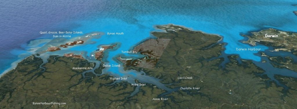
There are at least half a dozen boat ramps in the Finnis River & Bynoe Harbour area.
MILNE INLET – At Milne Inlet. Turn off Fog Bay Rd along Bynoe Haven Rd past Sand Palms Roadhouse and then Milne Road. Best with tides higher than 3 meters.
STINGRAY HEAD BEACH LAUNCH – Turn off Cox Peninsular Rd onto Fog Bay Road. About 55 km along Fog Bay Rd the road makes a sharp turn where the large Dundee sign is. Instead of heading to the lodge, follow the dirt track to Five Mile Beach.
DUNDEE – Turn off Cox Peninsular Road, the ramp is about 60km down Fog Bay Road. It is best to launch the boat with tides above 3 meters.
SIX PACK CREEK – At Mackenzie Arm. Turn off Fog Bay Road along Barramundi Drive. Best with tides higher than 2 meters.
At Mackenzie arm. Turn off Fog Bay Road along Dundee Road. Best with tides higher than 2 meters.
MOUTH OF ANNIES – If you are heading towards Cox Peninsular driving along Fog Bay Road there is a dirt track on the left 1.8 km past Lenny Creek. Follow the track to the end. Need a 4WD as it is necessary to drive onto sand to access launch site.
MOUTH OF FINNISS – Drive along 5 mile beach to the mouth of the Finniss. Launch boat off the beach – or – with permission from the Professional Fisherman’s Camp. Ramp is a couple of kilometers upstream continuing along a track from the mouth of the Finniss
River Road FINNIS River – Not Tidal. Take Hardcastle Road which is 500m before/after SandPalms Roadhouse on Fog Bay road then turn right about 3km along and go all the way down River road. River road and adjacent land floods in the wet season making access impossible for large periods of time. Check the NT Road Reports page and look for restriction alerts like this:
2017 Road Report Website Restrictions
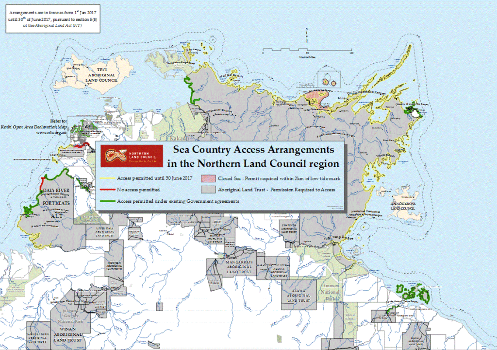
In December 2016 The Northern Land Council declared that a permit is required in relation to the areas marked in red on the Sea Country Access map. This is regardless of the six month waiver until 30 June 2017 on the requirements for a permit.
Arrangements in the Northern Land Council Region map, include:
…..(b) those parts of the Delissaville/Wagait/Larrakia Aboriginal Land Trust, more particularly described as the upper Finniss River.
Northern Land Council Sea Country Access Arrangements in the Northern Land Council region
It was supposed to be that from 1 July 2017 all commercial fishing operators and recreational fishers will require permission from Aboriginal land owners and the Northern Land Council (NLC) through the grant of a licence or permit to fish in tidal waters over Aboriginal land except in permitted access areas. But typical NT, this still doesn’t appear to be fully resolved!
Note: The Finniss River, access and fishing at River Road/Hardcastle road, has been highlighted as “No Access Permitted”. Time will tell as to whether this is fully implemented.
Crab Claw Island Resort– Private boat ramp to access the fabulous fishing. Turn off about 24 km from Cox Peninsula Rd – Fog Bay Road intersection. Dirt road – well sign posted. Great accommodation too!
Safety First! Make sure you have sufficient life jackets for every person on the boat.
Don’t go alone. Besides the safety aspects, it’s more fun. There are lots of dangers, don’t take risks in the Top End.
Check off the requirements at the NT Government Marine Safety site here.
Have the latest EPIRB – digital 406 MHz and it’s registered.
During the dry season in the Top End, weather conditions are pretty constant and ideal for fishing. During the wet season (November to May), the weather can change suddenly. Always check weather forecasts before departure. Always keep an eye on conditions whilst your pulling in that big fish! Find sheltered estuaries, creeks etc to ride out a storm should you get caught. Be aware winds and swells can blow in very fast.
Never choose to enter any water in the Top End no matter how deep or shallow.
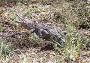
Salt water crocodiles can be found in both fresh and salt water everywhere.
Take care how and where you gut that fantastic fish! Don’t attract crocodiles by leaving food scraps around. Even fresh water crocs can bite!
Fill your boat a day or two before your planned departure. Don’t fill on the day. Fish will stay clear of the smell of fuel if you get some on you and subsequently your line and bait.
Don’t let fuel sit too long. In the tropical humid atmosphere petrol will absorb the moisture from the air and you may end up with engine problems. Make sure petrol caps are tight.
Similarly put sun screen on before departure and wash hands well with soap before leaving shore. Fish won’t bite bait affected with sun screens, especially those that are scented. Cover up. Use wide brim hats and long sleeves. The tropical sun burns!
Top End waters lined with mangroves and mud flats are the breeding grounds for mosquitoes, midges and sandflies. Flies come from nowhere. Spray with a reliable deterrent again before departure. Always keep some handy. It’s no fun getting eaten alive – fish or no fish.
Refrain from smoking whilst fishing. Firstly your boat is full of petrol that could ignite, but again, fish are not nicotine adicts and they will smell you a mile away.
Check your anchor chain and rope. D shackles have a tendency to work loose. The last thing you want is to throw your anchor over board only to find on its retrieval – your anchor’s gone.
Know your bag limits for different fish species. Check out the info here.
Check and know your tide times. No run – No fun! Best to fish on the change of a tide. In the Top End, 6-7m tide changes are common. Be aware that sand bars and rocky reefs may be just below the water in low tides. What water you travelled over an hour ago, may now be dangerous.
Heard about that big fish that got away? Too many Times? Suggest use braid rather than filament fishing line.
Use quality fishing leader line. Many a good fish has got away by breaking the line at its weakest point.
Way Points: Good starting point but also use navigation, depth sounders to finely adjust your boat to the edge of a reef, ledge or wreck, not directly over a hole etc.
Use freshest bait you can get. Don’t thaw and refreeze multiple times. Fish are picky eaters!
Always clean your boat, rods, reels, tackle, immediately at the end of each day no matter how tired you are! Your fishing gear will last longer and be ready as soon as the fish are biting. Fishing is enjoyable, exciting, but all that fresh sea air and sun can be tiring. Plan you travel and clean up taking this into account.
Take plenty of drinking water. The tropical sun and climate does take its toll, especially out fishing for a couple of hours.
Lures: Use heavy fly gear and medium sized fishing lures in bright bronze or gold metallic colours
Trolling and Casting: Use medium weight baits and lures (These won’t get blown and knocked around like smaller, lighter varietties.)
Peak Wet Season: December to March. Recommend cast from boats anchored in waterways close to banks and submerged logs
Dry Season: May to November. Try fresh water lagoons and rivers
Build Up: October to December. Barra are active as water temperatures rise in freshwater lagoons and in salt water estuarine waterways.
Tidal Rivers: Fish at the end of run-out tides
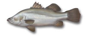
Estauries and Salt Water Creeks: Fish an hour or two either side of a low tide And when you hook a Barramundi, be prepared for an exciting battle of wits and strength with a worthy opponent.
Bynoe, Northern Territory to get better mobile coverage
Update:April 2018. The mobile tower on Hardcastle Road is complete and working!
Mobile phone coverage in the Bynoe Harbour and Finniss River area has been a significant issue for people living, working, holidaying and travelling in this part of the country for considerable time. In some locations reception is only possible using additional equipment such as a car kit, external antenna or repeater kits for rural & regional areas as handheld reception has been non existent. All an added expensive addition. Communication, especially in times of emergencies has and will have an impact on outcome.
The Australian Government has committed more than $200M to the Mobile Black Spot Program to improve mobile coverage along major regional transport routes and in small rural communities.
On 1 December 2016, the Australian Government announced that round 2 of the program will deliver 266 new or upgraded mobile base stations across the country with construction of base stations under round 2 of the program expected to commence in 2017/18.
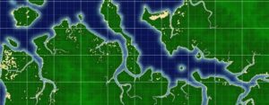
The good news is Bynoe in the Northern Territory has been funded to receive a Telstra macrocell. Better life, better travel, better holidays, better all round!
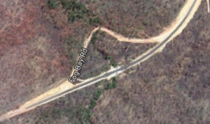
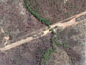
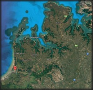
The map below indicates this tower is to be built at the corner of Fog Bay Road and Hardcastle Road.
In the May 2016 NTG Budget, Transport Capital for Top End Rural and Regional was announced.
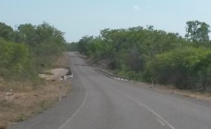
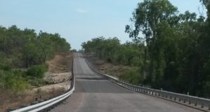
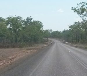
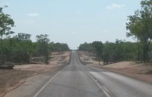
This included the completion of the Fog Bay Road upgrade at Rocky Creek Bridge and thus the final wet season obstacle addressed for Bynoe and Dundee residents and visitors.
Fog Bay Road has had a number of upgrades in recent times.
Annie River BridgeCharlotte River Bridge
Changing from being totally unsealed with no bridges to the current bituminised road with now all the rivers Charlotte, Annie, Rocky and Leviathan Creek now bridged.
Leviathan Creek BridgeLeviathan Creek Bridge Fog Bay Road
The 2016-17 budget allowed for continued funding to the existing upgrading of Leviathan Creek Bridge (now complete) as well as provide new funding for the Rock Creek Bridge crossing – the last crossing to be upgraded.
A total of $5.77 million of Northern Territory Government funding had been provided for Fog Bay Road in 2016-17. About $4M alone on the Leviathan Creek Bridge.
Rocky CreekRocky Creek Bridge Fog Bay Road
Construction of Rocky Creek Bridge was done under tender awarded to Allan King & Sons Construction Pty Ltd with a tender costing of $1,570,888. This was published by the Northern Terrory Goverment at the end of Novemeber 2016.
As the 2016-17 wet season like many before had resulted in Rocky Creek being impassable due to flooding and surface conditions ruined on numerous occasions the completion of road works before the 2017-18 wet season is a welcomed sight!
Fog Bay Road is now a much better all season road for residents and tourists alike.

 Australia’s Northern Territory is teeming with exotic birdlife, mammals, reptiles and marine life. The Finniss River and Bynoe Harbour included. The Finniss River coastal floodplain, about 70 km south-west of Darwin is dominated by seasonally inundated grassland and sedgeland with areas of paperbark open-forest. The Finniss River floodplain is also of international significance. This site is listed as a wetland of national significance in the Directory of Important Wetlands in Australia.
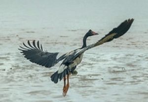 The area supports very large numbers of waterbirds, including more than 1% of the world’s populations of Magpie Geese and Pied Herons, and high densities of many other waterbird species. It supports important breeding activity by Saltwater Crocodiles, Magpie Geese and other waterbirds, and three
 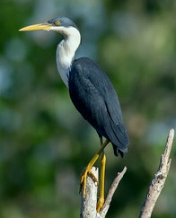 large waterbird breeding colonies are known to be located in paperbark swamps on the floodplain. Approximately five threatened birds and one threatened plant species also call this area home.
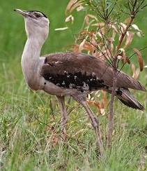 Masked Owl Tyto
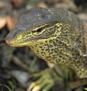
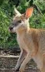 Wallaby are also very abundant.
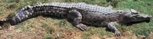 Floating grass mats of the billabongs of the Finniss and Reynolds Rivers not destroyed by buffalo, provide an important habitat refuge and source of food for a range of fauna in the dry season, especially crocodiles. There are more crocodiles in the Northern Territory than anywhere else in the world.
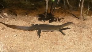
 There are at least half a dozen boat ramps in the Finnis River & Bynoe Harbour area.
 Trolling and Casting: Use medium weight baits and lures (These won’t get blown and knocked around like smaller, lighter varietties.)